Transforming Local Planning for the 21st Century
Partnering with MHCLG to transform digital planning, focusing on better national consistency, open data and clear standards.
FutureGov for MHCLG

Project Overview
While at TPX Impact I led a digital transformation project with the Ministry for Housing, Communities and Local Government (now DLUHC) to reimagine local plans for the 21st century. Working with 4 local authorities across the UK we set out to explore how we could digitally transform local plans into a standardised process and digital toolset to better empower policy makers and key planning stakeholders. Building on discovery research we had three objectives for this stage of the project:
- Digitally transform local plans into a standardised digital product/toolset for policy makers, planning inspectorate and local planning authority officers.
- Develop data standardisation across local plans, testing the new data standards through a digital prototype.
- Develop the outline for a standardised and digitally enhanced service model for developing and publishing digital local plans.
What we did:
Understanding the needs and pain points of key stakeholders: Conducted research interviews with planning inspectors, property developers and local planning authorities to understand their current experience in the planning process and identify key design opportunities to improve tools and process.
Re-inventing a new service architecture: Working Collaboratively with Local Planning authorities we mapped out the current planning process focusing on current bottlenecks and potential improvements. We co-created a plan with 4 LPAs for a new service architecture enabled by better digital tools, increasing internal efficiency, improving data reliability and standard for a more streamlined process
Enabling process improvement through better digital tools: We created a digital local plan platform which enables users to engage with local plans across the UK. The product creates a standard interaction pattern, geospatial planning data standards and digital tools across all local authorities.
Understanding pain points in the planning process and identifying opportunities
From our research with key policy makers, planners and other key stakeholders we uncovered several key areas within the planning process that could be improved across data, process and digital tools.
Data: Data on local plans and local policy making is an integral part to national data and knowledge management infrastructure, however several issues and bottlenecks exist which prevent standardisation at a national level. Firstly there is a lack of a data standard for local plans and policies with a high degree of variation across local authorities. Local planning authorities usually have their own individual ways of categorising data when developing local plans, leading to issues with interoperability at the national level. This often leads to a lack of visibility across national planning for central government teams but additionally affects local authorities which share their borders with close neighbours as siloed planning data isn’t actively shared across jurisdictions.
Planning Process: To understand areas of improvement in the current planning process we ran workshops with local authorities to map the current process. From doing this with a range of different authorities (urban, rural) we learned that the planning process in its current form is highly variational and dependent on the planning management styles of the local authority. For processes to be locally contextual and both interoperable there needs to be a balance of standardisation in process and workflows and autonomy to meet the locally specific needs of each authority. Building upon this, the variation and complexity in process often makes it difficult for third parties such as the planning inspectorate, property developers and other stakeholders to engage with local plans quickly and understand how they can integrate their own needs into the process.
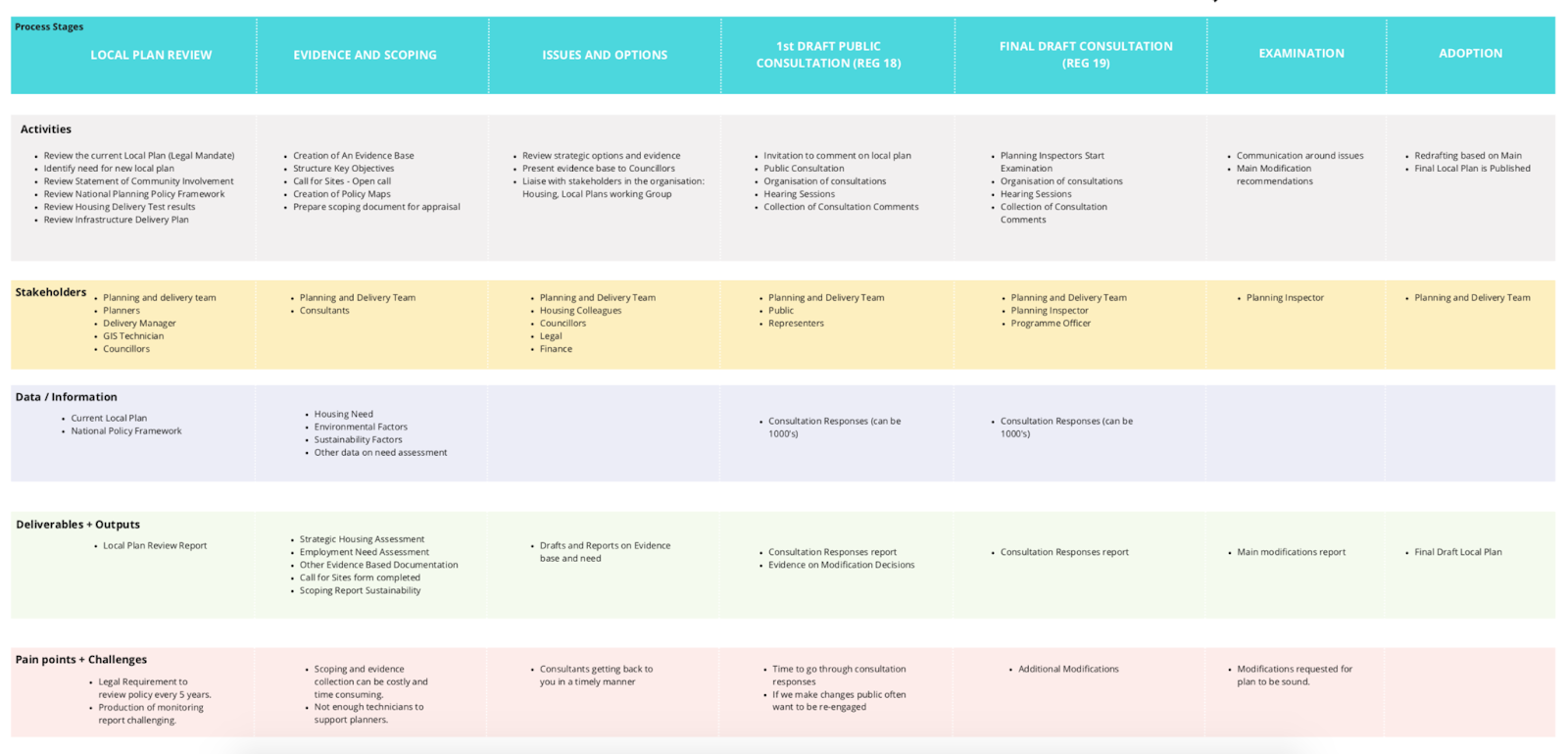
Mapping the current planning process and pain points with participating LPAs
Existing digital tools: After evaluating current digitisation efforts across participating LAs and within central government we uncovered several key barriers to address in our digital transformation effort. Firstly there is no design standard for policy, maps and evidence within local plans. This leads to experiences where users struggle to find information online and downstream effects where LPAs are frequently having to field queries from users. Building on this navigating complex information landscapes was also a challenge for users of local plans, often facing difficulty to navigate and locate information within the planning ecosystem.
Identifying opportunities to improve planning
By addressing the challenges that we uncovered through discovery research we identified the following opportunities to improve the planning process:
Data Transformation:
Data Standards: By creating a common data standard for how local plans are developed there is the opportunity to create a consistent national data framework across the planning system enabling better interoperability, data sharing and collaboration between stakeholders across central government, local authorities and the private sector.
Intelligent relationships: Between evidence, planning decisions and policies so that there is a clearly traceable provenance between decisions and the evidence that supports decisions.
Realtime data: Enabling a snapshot of where local plans are at in their development so that stakeholders have a better picture of how and when they can engage in the process.
Digital transformation opportunities, digital tools:
Digital plans reimagined as a centralised product for local plan that is easy to search and discovery Local Plans for each authority across the UK
Consistent design system and interaction patterns across all local plans providing the same user experience across planning authorities
Easily search local plans and find key information by improved information digitisation and search capabilities.
Digital transformation opportunities, processes:
Improve interoperability of data across local authorities and central government by creating a standardised framework and process for the development of local plans that is digital first, open and accessible.
Creating streamlined, transparent and accessible processes will enable planning stakeholders and communities to more effectively engage with local plans and reduce the co-ordination overhead currently experienced by LPAs.
Developing the Digital Local Plans Platform
To test out some of our ideas and harness the opportunities identified during research we developed an alpha prototype of a new digital planning platform. Working with 4 participating local authorities we audited and standardised planning data using our new categorisation framework, for more consistent and simpler planning and land use categorisation across the board. Following this, we developed a prototype platform based around the core needs of planning stakeholders. User groups could access open planning data, including an interactive map of plans and policies, an evidence base of research and studies supporting the planning decisions, community consultations and other key resources.
Testing our prototype: Over the duration of Alpha we worked in sprints to prototype and get feedback from planners, policy makers and prop tech companies, iterating our prototype to meet the needs of each user group. Building everything in the government design system to ensure compliance and meet accessibility requirements.
What we learned:
Building from the user needs we identified in Discovery we tested several key use cases with core user groups to understand if the solution meets current needs and where it can be improved. Some of the key use cases across user groups are as follows:
Planning Inspectorate:
- Have a centralised resource which easily links together core information needed for examinations such as evidence, policies, planning maps and other key documents.
- Being able to easily search and query the data on planning decisions, how local authorities arrived at their decision/decision making process and what evidence informed key policies was a key improvement from current ways of working, as the solution clearly linked how decisions were made.
- During the consultation phase ability to search consultation responses from the community and understand thematic points of contention that need to be resolved by the authority to achieve consensus and move the plan forward.
Local Planning Authority Officers:
- Understand how planning policies apply to specific development sites so that planning officials can make decisions on planning applications.
- To be able to get an overview of the status of plans for neighbouring authorities so that planning teams can effectively collaborate with neighbours on joint planning projects.
- Centralise my planning documentation so that it can be easily compiled and shared across collaborators and 3rd parties who engage in the planning process.
Policy Makers:
- Understand the underlying research and studies which constitute the evidence base and use it to inform policy making decisions that are evidence based decisions.
- To understand the history of a development site so that policy makers can create policies that are contextually appropriate to the area.
- Understand the relationship and interlinkages between policies at a local and national level to create a high degree of planning synergy between local and national policies.
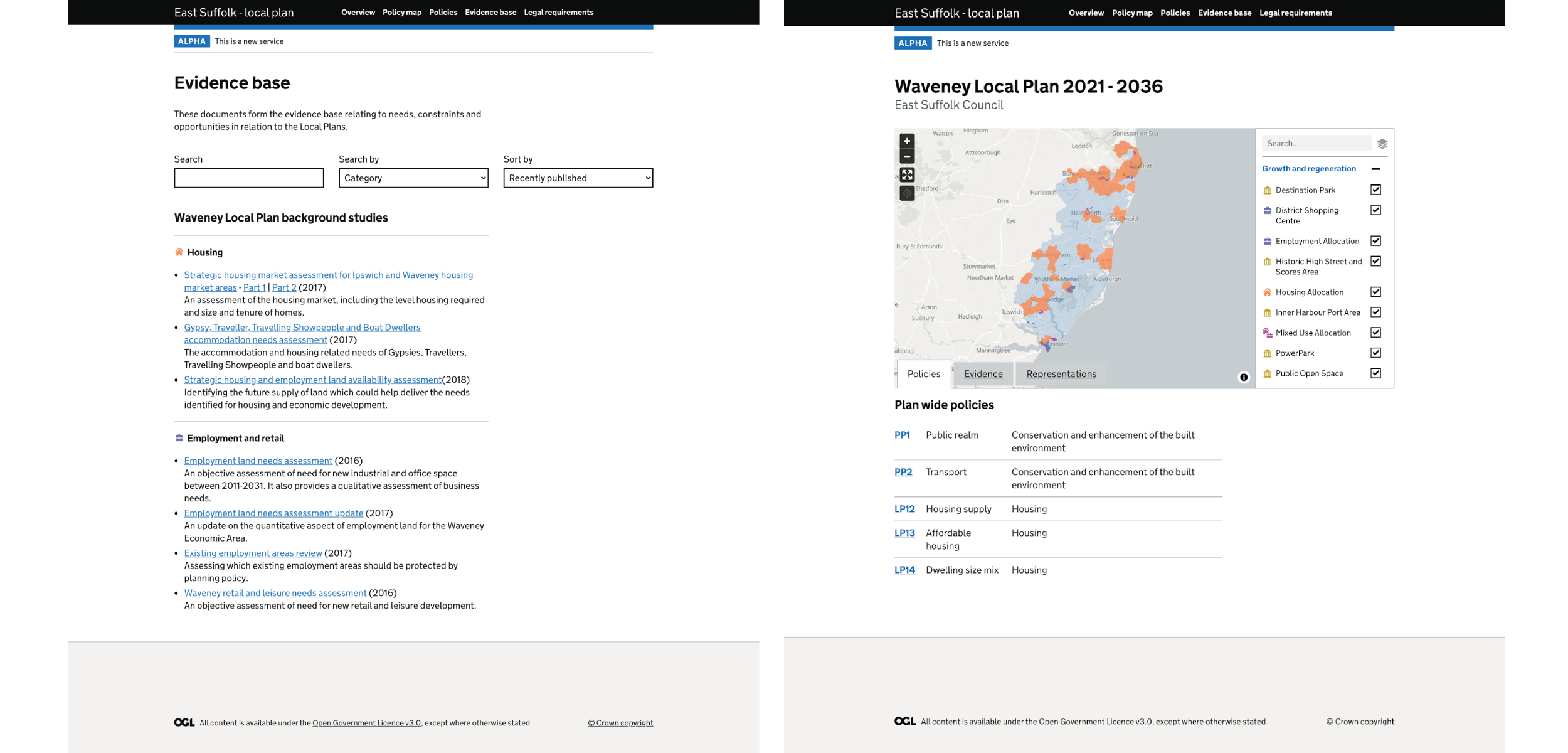
Digital Platform created of the new planning platform and data standard
Next Steps
For the next steps of the project move on to scaling up the pathfinder programme to include more local authorities to continue to test and scale the new digitally enabled planning approach across a wider range of local authorities and planning stakeholders.
- Hero Image - Tom rumble, published under Unsplash License. https://unsplash.com/photos/7lvzopTxjOU